Instrument navigation in the Viking Age?
It is almost impossible for modern humans to imagine that it is possible to make long voyages over the open sea without some form of navigation instrument. But although some implements are known from the Viking era that may have acted as navigation instruments, we cannot be sure that the Vikings used anything except their senses to find their way.
There is very little evidence of the Vikings’ use of actual navigation instruments. Much of the research has therefore focused on what instruments the Vikings could have had with the materials and the technology that they had available.
Regarding actual instruments, the Vikings may have been able to measure the following:
- Water depth
- Speed (time)
- Course
- Latitude (height of the sun).
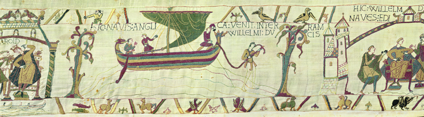
The water depth can be sounded with a lead weight on a string or a pole can be used for shallower depths. Lead weights have been found in Viking era harbours and soundings with a pole were illustrated in the Bayeux tapestry in the 11th century.
Sun Compass
The Vikings probably used a sun compass. A sun sompass always shows the correct direction. This comprises a vertical pointer on a horizontal surface, on which the shadow of the pointer, the so-called gnomon, is drawn through the day. This shadow curve is different at different latitudes and at different times of the year, so in order to use it for navigation, a series of curves is necessary.
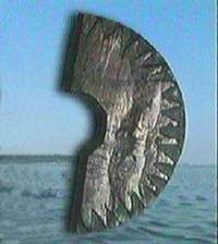
Fact: During an excavation of a Viking Age farm in Greenland in 1948 part of a circular disk with carvings was recovered which could be just such shadow curves. In addition, the historian Olaus Magnus mentions in 1555 a Nauticus Gnomon, which could also be such a compass.
When the sun is obscured by clouds even the sun compass has its limits. But we have from the sagas knowledge of so-called “sun stones”, which could determine the direction of the sun even under cloud cover. This could be a mineral, which polarises light. But so far a clearly suitable mineral has not been found and there are no archaeological finds of “sun stones”.
The determination of latitude by measuring the height of the sun at midday is similarly not known from Viking times. If the aim was solely to determine whether the ship remained at the same latitude or deviated to the north or south, the observation could be made with a simple homemade instrument. The problem is that the height of the sun (declination) changes through the year. It is, therefore, necessary to have a declination table if the journey extends over a longer period. Just around mid-summer there is, however, a time where the variations in declination are so small they are of no practical significance.
Even measurements of the sun’s height were carried out long prior to the Viking Age in other parts of the world with instruments such as the astrolabe or quadrant but there is no evidence that these were used in the Nordic Countries. A instrument, which was used in the past on the Faroe Islands, could, conversely, have been inherited from the Vikings: The so-called sólskyggafjól (“sun shadow stick”) comprises a pointer, which throws a shadow onto an horizontal plate which, for example, is floating in a water bath. At given latitude, the shadow of the pointer will strike a particular circle around the plate. If the pointer can be extended and retracted, or a number of circles are drawn on the plate, the instrument can be used at several latitudes.
Mikkel H. Thomsen - with contributions by Lena Börjesson and Max Vinner